The road to Australia's spiritual centre (Uluru) is a long and boring one. There is not much to see on the road before you reach Alice Springs except for the Devils Marbles about 400km north of Alice Springs. This was also the first place we stopped except for eating and sleeping. Devils Marbles are a collection of round stones often balancing on top of each other forming an interesting and seemingly impossible landscape. They are situated not far from the highway with the surrounding area being pretty much flat. My first reaction was wondering how these round balls of rock don't roll off. The answer I don't know, but I am sure it's more logical than it looks. We arrived in the afternoon with he sun low in the sky and the perfect light for taking great photos. I walked around and marveled at yet another great natural wonder that Australia has so many off.


 Uluru-Kata Tjuta national park is made up of Uluru and another rock/mountain formation called Kata Tjuta (The Olgas). Because we wanted to watch the sunset over Uluru we decided to go to Kata Tjuta first. Kata Tjuta is a series of large rocks/mountains sticking up from the flat landscape. They are different from the Uluru rock and unique in their own way. We first stopped at a lookout and made some panorama shots before going on a short walk next to one of the "domes". It was very interesting to walk next to this weird stone. I remember thinking how amazing it is that these structures are located out in the middle of the desert sticking right out of the landscape. It is hard to try and explain how The Olgas look, so I hope these photos do the job. We also enjoyed a nice lunch next to Kata Tjuta before heading towards Uluru.

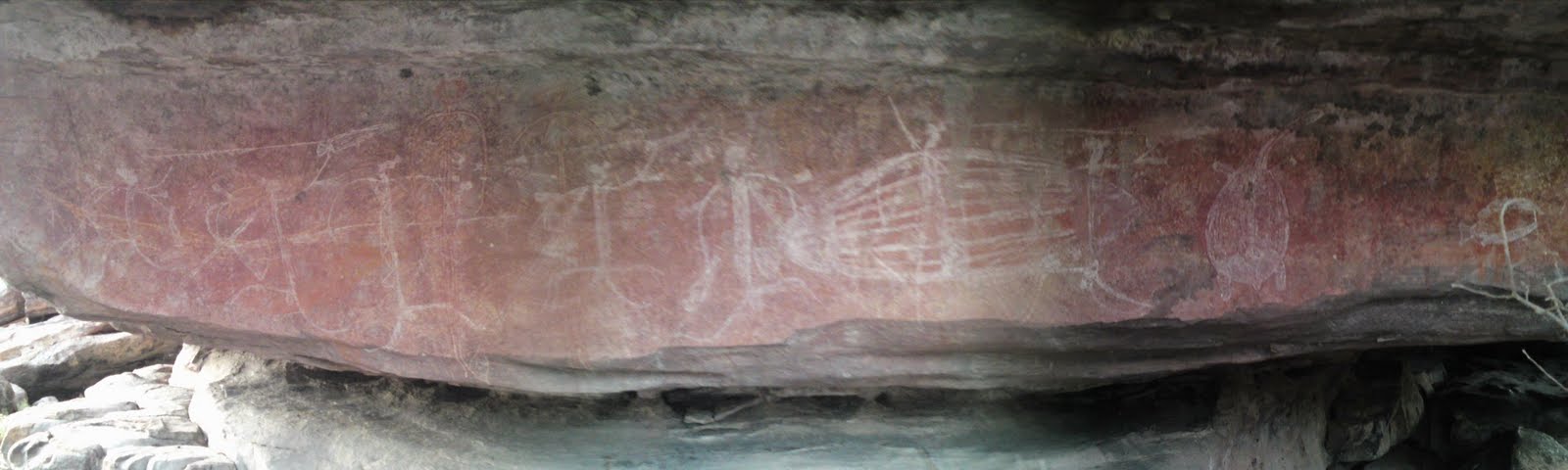
 Uluru is just 30 minutes away from Kata Tjuta and the red rock rises majestically towards you as you get closer. It is not as big as I had imagined, but it is definitely not small and very impressive non the less. I have heard that people just call it "a rock" but I say it's a very cool rock. There are several places of interest around the bottom of Uluru, a walk that takes you completely around it and a climb to the top. The Aboriginals ask that you don't climb out of respect so we decided to walk along next to it to a place called Kantju Gorge. Along the base of Ayers Rock are many dents and "caves". Some have aboriginal rock art. Looking upwards you can see the uneven shape of the rock and the places where the water flows down when it rains. The further we went the more interesting it became. Sadly we only had time for one walk before we drove out to the sunset viewing area. We even got there a little bit to late with the sun just behind the hills. We still got some great shots and a day full of natural wonders.


 It was now pitch black and driving on the gravel road was a bit of a challenge. Luckily we got to the other side where the sealed road was without problems, or so we thought! We soon realized that something was wrong. First the blinkers stopped working. Then the CD player switched itself on and off continuously. We stopped at the side of the road to have a look what could be wrong and not finding anything we tried to start the car again. But now it didn't want to start. We where now stuck 150km from the nearest roadhouse in the middle of the night. Luckily after just 5 minutes two cars passed us and stopped to help. It turned out to be a family from South Australia. They were extremely nice and helpful. The problem was that the battery was flat so they jumpstarted us. But just five minutes down the road the gas stopped working and the car died while driving. Our alternator was not charging the battery anymore. They then drove the 150km to the roadhouse borrowed a rope and came back. Since they anyways were heading the same place like us they towed our car all the way to Yulara, the small town next to Uluru. Here they dropped us close to the car mechanic. We even woke up the next morning with a great view of Ayers Rock and the sunrise. In our bad luck of having our car breaking down we got extremely lucky. Not only was the family that helped us the only people we saw on the road that whole night, but in the end the problem was our immobilizer. It broke from the battery going empty and stopped the fuel injection. The mechanic disabled it, charged our battery and we were on our way once again.

 It is another 300km from Uluru to Kings Canyon. We arrived by midday and decided to do the walk along the edge of the canyon called the Rim walk. It was 6km long. Kings Canyon is a spectacular sight. The path first took us up the steep canyon wall before running along the edge. Sometimes it also went away from the edge and into amazing stone dome formations. There were several great lookouts with breathtaking views of the valley below and the canyon walls. Some places the wall was 100% vertical. About half way through the walk the path went down into a small valley called the Garden of Eden. Here there is permanent water and lush plants and trees grow making it a popular place for animals to find shelter from the harsh landscape all around. Although Uluru is much more famous and visited, Kings Canyon is equally fascinating and deserves to be visited as well.
From Kings Canyon the road is once again gravel and a permit is required because it runs on Aboriginal land. We had already obtained a permit from the Information Centre in Alice Springs and started the drive along the Mereenie Loop as it is called. The landscape around us as we drove was very scenic and the road was fun to drive as well. The Mereenie Loop is part of the Red Centre Way. A loop from Alice Springs through the West MacDonnell ranges and past Kings Canyon and Uluru. We camped that night at a place called Gosse Bluff.


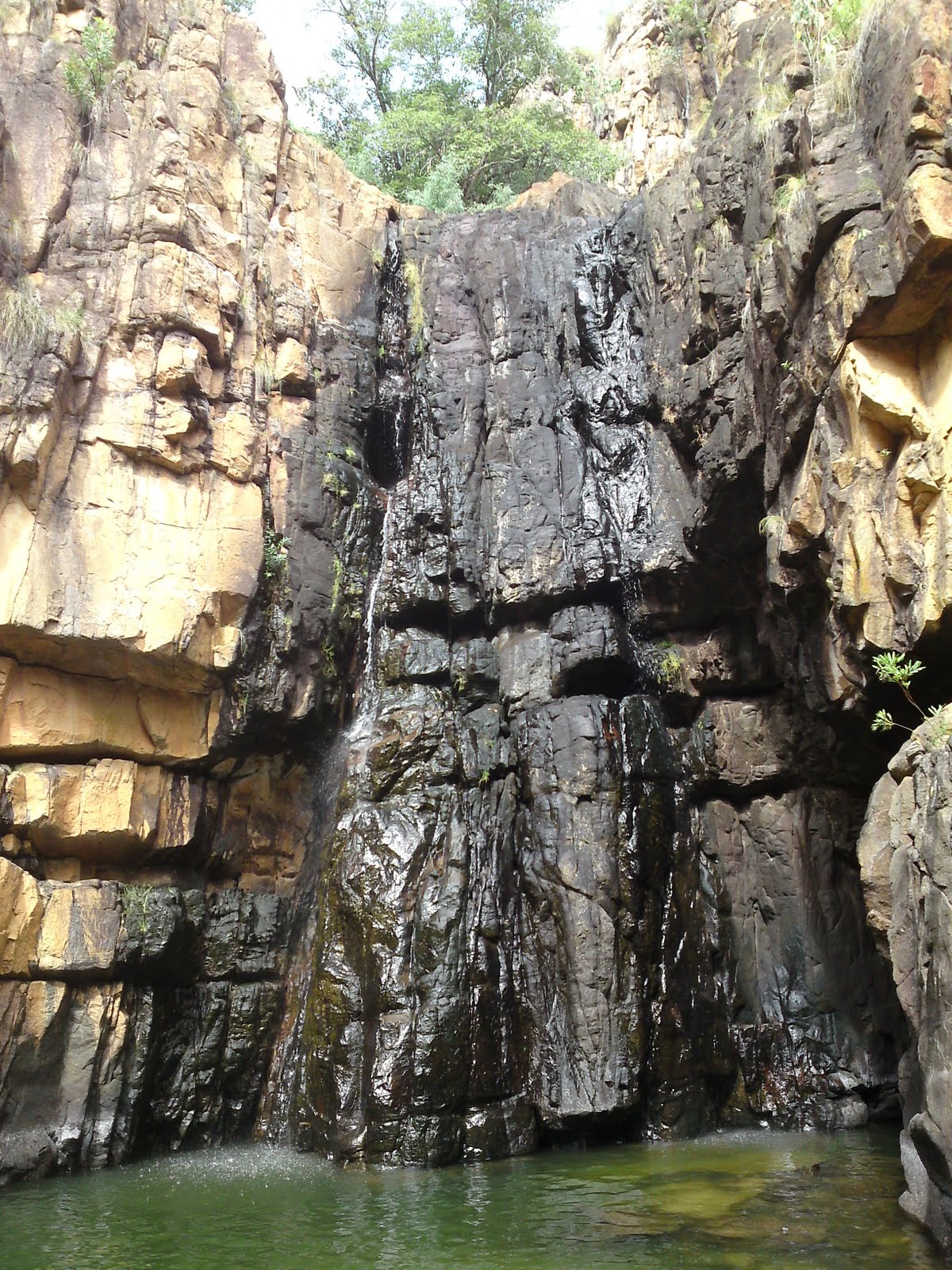
 The West MacDonnell ranges are a spectacular sight. The road runs next to the hills which were formed like half barrels next to each other. Along the main road were turnoffs to various points of interest. We stopped at a few of them including Ellery Creek Big Hole and Standley Chasm. Ellery Creek Big Hole is a nice swimming spot where the Ellery creek cuts it's way through the hills. It was a beautiful place. The water was cold and we didn't feel like swimming so we went on a short walk through the hills instead. Standley Chasm was equally beautiful. At midday the chasm catches the suns light and the walls turn orange/red. It was a spectacular place even without the color changes. I always thought that the centre of Australia is Uluru and not much more. But the fact is that there are heaps of amazing things to see.
 The road to Cairns from Alice Springs is also long and boring. But there was a few things worth mentioning. First off we passed the Tropic of Capricorn, the "line" where the tropics officially start. Not that there was palms on the other side or anything :P. We have crossed the Tropic of Capricorn a number of times already during our travels, but I haven't commented on it until now. We also shortly stopped at a small place called Wycliffe Well which claims to be the UFO capitol of Australia. It was half roadhouse/half museum and actually a bit interesting. We passed the Devils Marbles again as well and stopped and explored a new section we didn't last time. I got more great photos. From there and to the Queensland border the landscape was more or less empty and flat with nothing of interest worth seeing.